


| Valle de Puértolas - Puyarruego |
| Home | Excursions | Navateros | Lafortunada | Muriello | Ascaso | Fruits |
|
|
|
|
| Nederlands | Ruta de los Navateros |
Castellano |
 |
The beginning of the marked trail lies
near the camp-site in the last curve of the access road to the village.
The path runs on the northern slope towards the village square. As the
last stretch is rather steep, some people could probably better start
the walk directly from the Plaza Mayor.
The Ruta de los Navateros is in fact the old connection path between Puyarruego and Escalona that was cleared and signposted. The path is situated on the right bank of the Río Bellos and is about three kilometres long from begin to end. There is one small difficulty: the old bridge over the Río Yesa is gone. That could make it a bit difficult to cross the river during winter. The river is almost dry in summer. Several interpretative panels are planted along the way. They explain the landscape, vegetation, plants and their use, village life in past times, etc. Repeat your Spanish vocabulary: all text is Spanish only. I'm sure that the excursion is most enjoyable without the panels. But, still, I'm glad to point you to some interesting knowledge. |
| The panels at the village-green
relate the story of the Bardaxís (A village with a history). From the Plaza Mayor the village mill is visible deep in the valley. The mill stems from the 16th century and from 1920 served as a power station. The mill was shut down in 1980. (More about the mill) Puyarruego was a community of wood-cutters and navateros floating the logs as rafts to the Río Ebro and the Mediterranean. (More about the Navateros in Dutch) |
 |
|
| 16th century mill |
| There is still some discussion about the origin of the name Puyarruego. Some people think it relates to
the red colour of the upper layers of the earth, kind of a
pudding-stone named mallacán.
The traditional houses in the village all feature a bodega (cellar) excavated
in this red layer. The layer there below is grey.
If you look carefully you'll find the very same terrace of Puyarruego back at the other side of the river, at the same level next to Belsierre and a bit further near Laspuña. The mayor crop is corn. At the lower terraces near Escalona you'll find the vegetable gardens of the surrounding villages. |
 |
|
| Traditional barns |
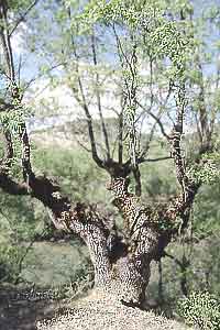 |
The path crosses several vegetation types. The slopes are covered with mixed oak-wood with several, sometimes beautiful, old ilex (carrascal - the emblem of the Sobrarbe region). The acorns where served to the hogs. The wood was too hard for cabinet wood and was used for mortars, ploughs or found its end as charcoal (bringing us to another lost trade). Boxtree is another common species (Buxus), Spanish = Boj, Bucho = Aragonés. You'll find it edging much of the path.
In this manner it is an excellent give-away of former paths in the landscape.
In the river-bed grows a species of willow (sarga). She grows very fast and enthousiastic and in this way is a good fixative and bottom builder. The twigs are used for baskets and for the navatas (rafts). The willow twigs kept the logs together and could stand the forces of 40 tons of wood kneaded by the wild waters of the Río Cinca. |
 |
 |
 |
From Escalona the path
continues along the Río Cinca. Modern constructions invade the
the unkept vegetable gardens. Eventually You'll reach the bridge to
Laspuña where the first signs for the
Ecomuseo de las Navatas are already waiting for you.
Dispersed along the run of the Ecomuseum (also named Ecomuseo Pallaruelo.) are several interpretative panels and a life size navata. |
|
| Río Cinca with Laspuña |
 |
 |
|
| Navata | Ecomuseo Pallaruelo |